ConnectGalaxy Logo
    • Gelişmiş Arama
  • Konuk
    • Giriş
    • Kayıt
    • Gece modu
Satpalda Cover Image
User Image
Kapağı yeniden konumlandırmak için sürükleyin
Satpalda Profile Picture
Satpalda

@satpalda

  • Zaman çizelgesi
  • Gruplar
  • Beğeniler
  • Arkadaşlar
  • Resimler
  • Videolar
  • Makaralar
Satpalda profile picture Satpalda profile picture
Satpalda
18 w

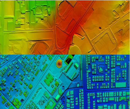
High-Resolution Digital Terrain Model (DTM) Services – Satpalda Geospatial Solutions

Discover precise and high-quality Digital Terrain Model (DTM) data with Satpalda, a leading geospatial service provider. Enhance your projects in civil engineering, hydrology, and land management with accurate terrain modeling and analysis. For more content us our official website. https://satpalda.co/digital-terrain-model-dtm/

Digital terrain model (DTM) | Digital elevation model (DEM) | Satpalda
satpalda.co

Digital terrain model (DTM) | Digital elevation model (DEM) | Satpalda

Digital terrain model (DTM), also known as Digital elevation model (DEM), is the practice of creating a digital representation of ground topography and terrain.
Beğen
Yorum Yap
Paylaş
Satpalda profile picture Satpalda profile picture
Satpalda
18 w

How are modern cities becoming smarter, more efficient, and sustainable?
Find out in Satpalda’s latest blog: “How GIS Surveys Are Used in Smart City Development.”
Geographic Information System (GIS) surveys are playing a critical role in designing the cities of tomorrow—enabling real-time data visualization, efficient infrastructure planning, and smarter governance. 💡 Whether you're a city planner, engineer, or tech enthusiast, this blog explains why GIS is the backbone of every successful smart city initiative.
👉 Read the full article now: https://satpalda.co/how-gis-su....rveys-are-used-in-sm

GIS Surveys Are Used in Smart City

A good town runs on plans. A map helps set that plan. But how? Geospatial tools track landand show what to build.
Beğen
Yorum Yap
Paylaş
Satpalda profile picture Satpalda profile picture
Satpalda
19 w

Explore Satpalda’s latest blog, “How AI is Enhancing Satellite Image Analysis,” and see how artificial intelligence is transforming the way we analyze Earth from space.
From automated land cover classification to real-time disaster monitoring, AI is streamlining workflows, increasing accuracy, and opening up new frontiers in geospatial intelligence.
🔹 Learn how AI accelerates image processing
🔹 Discover its role in land use mapping, agriculture, urban planning, and more
🔹 Find out why AI-driven analysis is becoming the new industry standard
👉 Read the full blog now: https://satpalda.co/how-ai-enh....ancing-satellite-ima

How AI Enhancing Satellite Image Analysis - SATPALDA

AI reads what the eye can’t see. Artificial satellite shots hold tons of facts, but they need AIto pick the key ones.
Beğen
Yorum Yap
Paylaş
Satpalda profile picture Satpalda profile picture
Satpalda
19 w

At Satpalda, we’re exploring how Artificial Intelligence is revolutionizing the way satellite imagery is processed, interpreted, and applied across industries.
In our latest blog, learn how AI-powered tools: ✅ Automate object detection
✅ Enhance land use classification
✅ Improve change detection
✅ Accelerate data interpretation for faster decision-making
Whether you're in agriculture, urban planning, defense, or environmental monitoring, this is a game-changer.
🔗 Dive into the details: https://satpalda.co/how-ai-enh....ancing-satellite-ima

#ai #satelliteimagery #geospatial #remotesensing #imageanalysis #satpalda #artificialintelligence #gis #smarttech

How AI Enhancing Satellite Image Analysis - SATPALDA

AI reads what the eye can’t see. Artificial satellite shots hold tons of facts, but they need AIto pick the key ones.
Beğen
Yorum Yap
Paylaş
Satpalda profile picture Satpalda profile picture
Satpalda Onun profil resimlerini değiştirdi
19 w

image
Beğen
Yorum Yap
Paylaş
 Daha fazla Mesajları yükle
    Bilgi
    • Erkek
    • Mesajları 6
  • Bulunan 1006, Kanchenjunga Building, 18, Barakhamba Road, New Delhi - 110001, India
  • https://satpalda.com/
Yaklaşık

Satpalda Geospatial Services is a leading provider of satellite imagery and geospatial services and solutions to the user community. The company continues to successfully deliver a wide range of Photogrammetric and Remote Sensing Projects. Our cost-effective solutions cater to the broad spectrum of government and industry users.
    Albümler 
    (0)
    Arkadaşlar 
    (0)
    Beğeniler 
    (1)
    Gruplar 
    (0)

© 2025 ConnectGalaxy

Dil

  • Yaklaşık
  • Rehber
  • Blog
  • Bize Ulaşın
  • Geliştiriciler
  • daha
    • Gizlilik Politikası
    • Kullanım Şartları
    • Geri ödeme istemek
    • Data Deletion Policy
    • Cookie Policy

Arkadaşlıktan Çıkar

Arkadaşlık etmek istediğinden emin misin?

Bu kullanıcıyı rapor et

Önemli!

Bu üyeyi ailenden kaldırmak istediğinizden emin misiniz?

poked var Satpalda

Yeni üye, aileniz listesine başarıyla eklendi!

Avatarını kırp

avatar

© 2025 ConnectGalaxy

  • Ana Sayfa
  • Yaklaşık
  • Bize Ulaşın
  • Gizlilik Politikası
  • Kullanım Şartları
  • Geri ödeme istemek
  • Blog
  • Geliştiriciler
  • daha
    • Data Deletion Policy
    • Cookie Policy
  • Dil

© 2025 ConnectGalaxy

  • Ana Sayfa
  • Yaklaşık
  • Bize Ulaşın
  • Gizlilik Politikası
  • Kullanım Şartları
  • Geri ödeme istemek
  • Blog
  • Geliştiriciler
  • daha
    • Data Deletion Policy
    • Cookie Policy
  • Dil

Yorum başarıyla bildirildi.

Mesaj, zaman çizelgesine başarıyla eklendi!

5000 arkadaşınızla ilgili sınırınıza ulaştınız!

Dosya boyutu hatası: Dosya limiti aştı (92 MB) ve yüklenemiyor.

Videonuz işleniyor, ne zaman görüntülenmeye hazır olduğunda size haber vereceğiz.

Dosya yüklenemiyor: Bu dosya türü desteklenmiyor.

Yüklediğiniz resimdeki bazı yetişkinlere uygun içerik tespit ettik, bu nedenle yükleme işleminizi reddetti.

Bir gruptaki yayını paylaş

Bir sayfada paylaş

Kullanıcıya paylaş

Gönderiniz gönderildi, içeriğinizi yakında inceleyeceğiz.

Resim, video ve ses dosyası yüklemek için profesyonel üyeye yükseltmelisiniz. Pro'ya yükselt

Teklifi Düzenle

0%

Katman eklemek


Bir resim seçin
Seviyeni sil
Bu kademeyi silmek istediğinize emin misiniz?

yorumlar

İçeriğinizi ve gönderilerinizi satmak için birkaç paket oluşturarak başlayın. Para kazanma

Cüzdan tarafından ödeme

Paket Ekle

Adresinizi Sil

Bu adresi silmek istediğinize emin misiniz?

Para kazanma paketinizi kaldırın

Bu paketi silmek istediğinizden emin misiniz?

Abonelikten çık

Bu kullanıcının aboneliğinden çıkmak istediğinizden emin misiniz? Para kazandıran içeriklerin hiçbirini görüntüleyemeyeceğinizi unutmayın.

Ödeme uyarısı

Öğeleri satın almak üzeresiniz, devam etmek ister misiniz?
Geri ödeme istemek

Dil

  • Arabic
  • Bengali
  • Chinese
  • Croatian
  • Danish
  • Dutch
  • English
  • Filipino
  • French
  • German
  • Hebrew
  • Hindi
  • Indonesian
  • Italian
  • Japanese
  • Korean
  • Persian
  • Portuguese
  • Russian
  • Spanish
  • Swedish
  • Turkish
  • Urdu
  • Vietnamese